Glaciers in Iceland cover about a tenth of the country, and the easiest place to see them is the south coast. Between Sólheimajökull and Höfn, tongues of ice from the Mýrdalsjökull and Vatnajökull ice caps reach down almost to the Ring Road. You can see them for free from viewpoints and lagoon shores. To walk on the ice or go into an ice cave you need a certified guide. This guide covers where the glaciers are, what you can do on them, when to go and how to stay safe.
How much of Iceland is covered by glaciers?
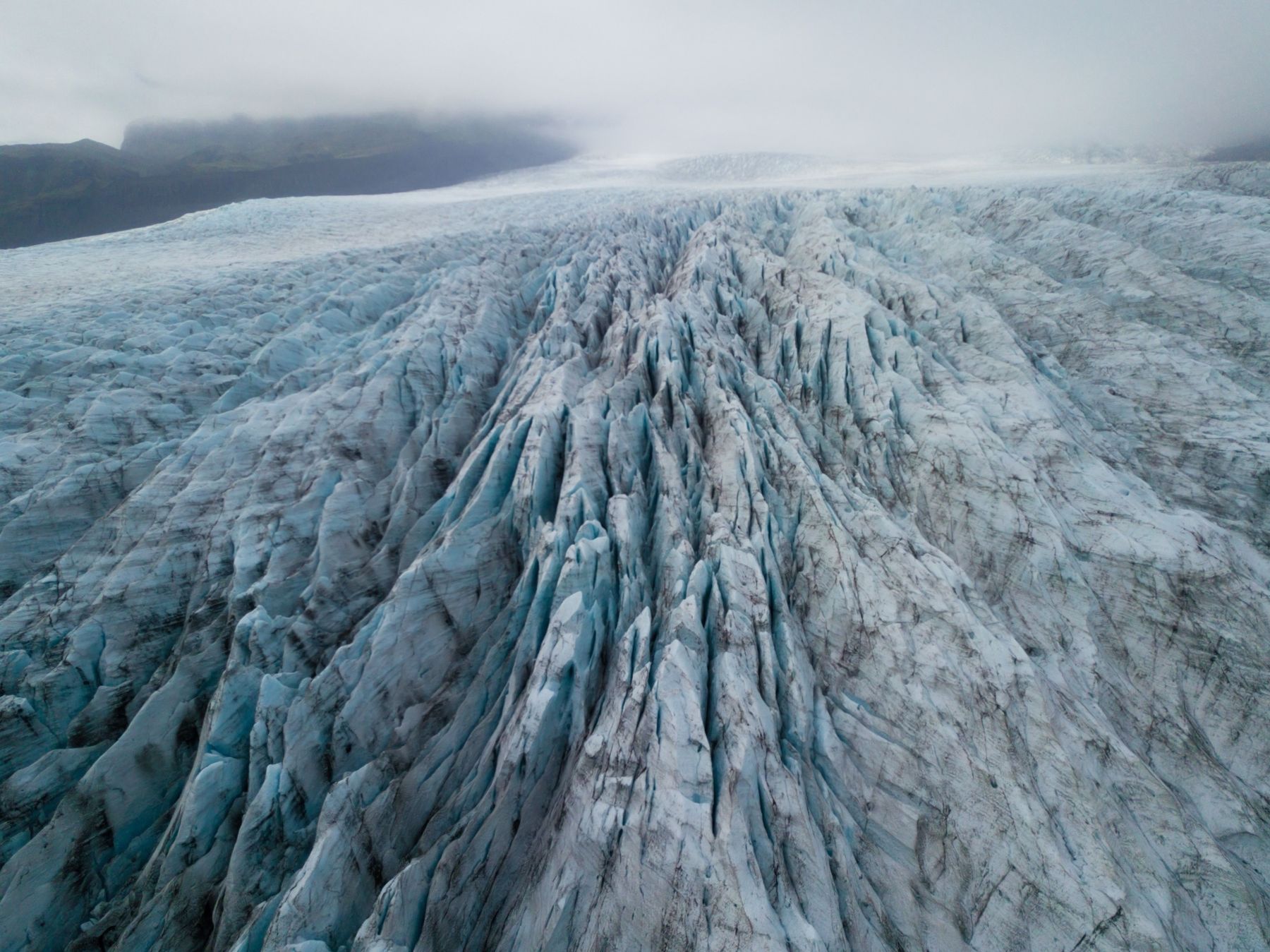
About 10% of Iceland was under glacier ice in 2019, roughly 10,400 km². In 2008 the figure was about 11%. There are more than 400 glaciers, but most are small, and a handful of large ice caps hold nearly all the ice.
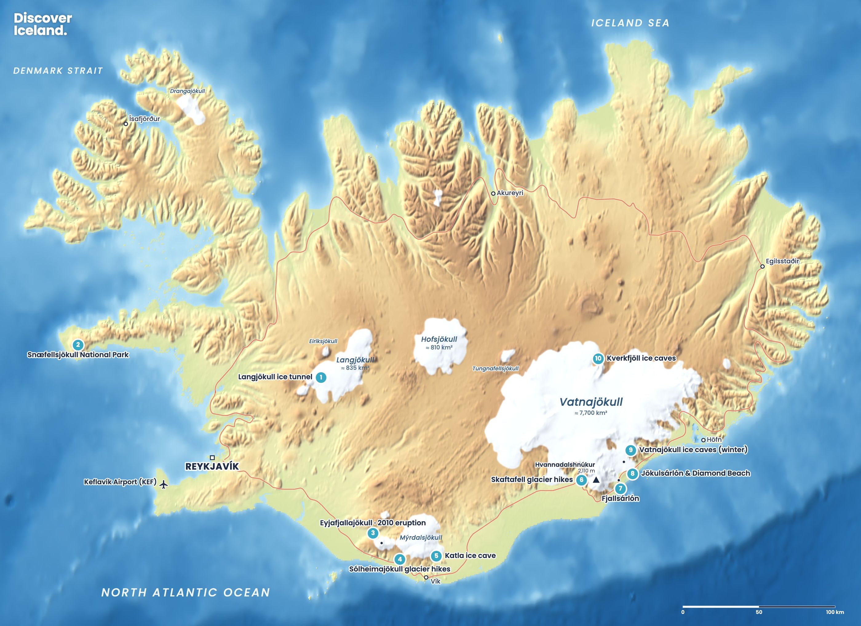
Vatnajökull is by far the biggest. It covers about 7,720 km², about three-quarters of all the glacier area in Iceland. These are the largest glaciers by area, from the 2019 figures.
| Glacier | Area (2019) | Where | How most visitors see it |
|---|---|---|---|
| Vatnajökull | 7,720 km² | Southeast | Skaftafell, Jökulsárlón, Fjallsárlón, ice caves |
| Langjökull | 836 km² | West highlands | Ice tunnel and snowmobile tours |
| Hofsjökull | 810 km² | Central highlands | From highland roads in summer |
| Mýrdalsjökull | 520 km² | South coast | Sólheimajökull, Katla ice cave |
| Drangajökull | 137 km² | Westfjords | Remote; seen on long hikes |
| Eyjafjallajökull | 66 km² | South coast | From Route 1 near Seljalandsfoss |
| Snæfellsjökull | 8.8 km² | Snæfellsnes | From the peninsula roads |
Several of Iceland's ice caps sit on active volcanoes. Katla lies under Mýrdalsjökull, and Öræfajökull, the volcano under the southern edge of Vatnajökull, carries Hvannadalshnúkur, the country's highest peak at about 2,110 m.
Where are the best places to see glaciers in Iceland?
The best places are on the south coast, along Route 1 from Sólheimajökull to Höfn. Here you can park, walk for 15 to 45 minutes and stand in front of a glacier tongue or a lagoon full of icebergs. These are the main stops from west to east.
- Sólheimajökull: an outlet of Mýrdalsjökull, about 2.5 hours from Reykjavík. A short trail leads from the car park towards the ash-streaked ice. It is the most popular place for guided glacier hikes near the capital.
- Skaftafell: the hiking hub of Vatnajökull National Park, 325 km from Reykjavík. A flat trail of about 1.8 km leads to a viewpoint at Skaftafellsjökull, and guided hikes start at the visitor centre.
- Fjallsárlón: a smaller, quieter lagoon about 10 km west of Jökulsárlón, where the glacier wall is close to the shore.
- Jökulsárlón and Diamond Beach: Iceland's best-known glacier lagoon, with icebergs that drift under the bridge and wash up on the black sand across the road.
- Heinabergslón: a lagoon at the end of a gravel road about 30 minutes from Höfn, used for summer kayak trips.
Away from the south coast, you can see Snæfellsjökull from most of the Snæfellsnes peninsula, and Langjökull from the highland edge beyond Gullfoss. Neither is as easy to get close to without a tour.
Can you walk on a glacier in Iceland?
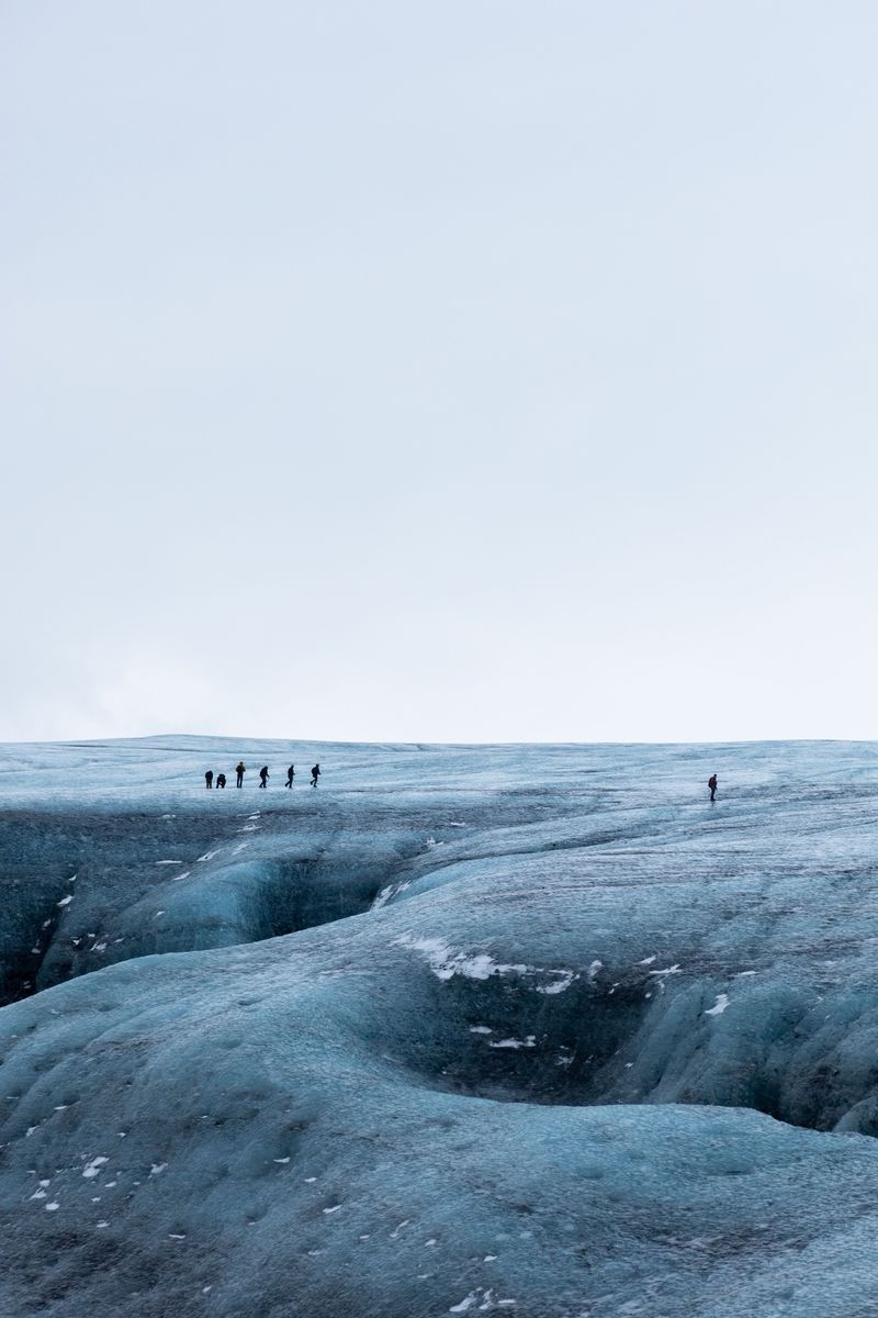
Yes, but only on a guided tour. Glacier ice has crevasses hidden under thin snow, deep meltwater channels and edges that collapse without warning. Guides check the route every day, fit you with crampons and a harness, and know when to turn back. Walking onto the ice on your own is dangerous, and rescue is slow and difficult.
The two main areas for glacier hikes are Sólheimajökull on the south coast and Falljökull near Skaftafell. Both run all year, and standard walks of about three to four hours suit most fit people. Most operators accept children from about 8 or 10 years old. Our guide to choosing a glacier hike compares them in detail, and our page on glacier hikes shows what the ice looks like.
Guided only: never step onto glacier ice, stranded icebergs or an ice cave without a certified guide. Viewpoints and marked trails let you get close safely.
When can you visit an ice cave in Iceland?
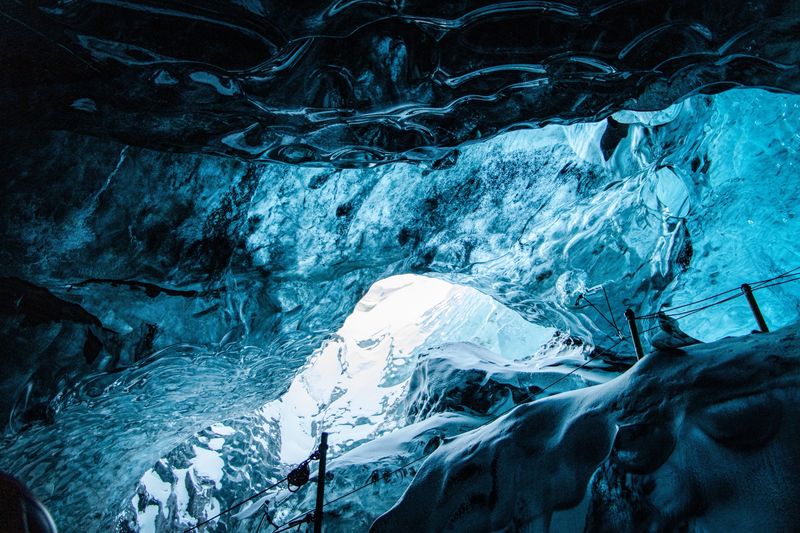
The natural blue ice caves in Vatnajökull are a winter activity. Tours run from about October or November to March or April, when the ice is cold and stable, and the caves are closed from May to September. The exact start depends on the weather each year.
If you travel in summer, the Katla ice cave near Vík is open all year, and Into the Glacier on Langjökull is a man-made tunnel you can visit in any season. Our ice cave guide explains the difference, the safety rules and how to choose a tour, and our ice caves page has photos.
What are Iceland's glacier lagoons?
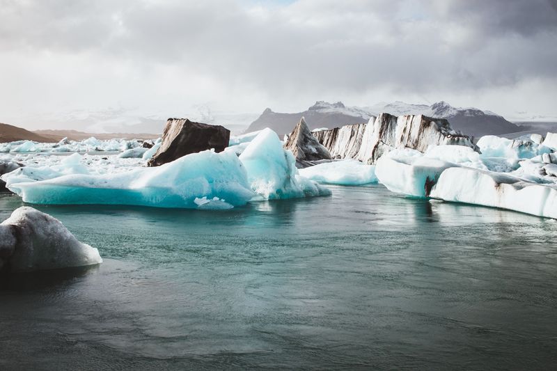
Glacier lagoons are lakes that form in front of a glacier as it melts back. Icebergs break off the glacier front and float in the lagoon, sometimes for years, before drifting out or melting. The south coast has several, all fed by Vatnajökull.
Jökulsárlón is the largest and most visited. It formed in the 1930s and is now about 25 km² and up to 284 m deep, one of the deepest lakes in Iceland. Its ice flows out under the Route 1 bridge and washes up on Diamond Beach. Read our complete guide to Jökulsárlón and Diamond Beach for parking, boat tours and the best time to go.
Fjallsárlón, 10 km to the west, is smaller and quieter, and lies right below the steep Fjallsjökull glacier. Breiðárlón and Heinabergslón are further off the main road. Our guide to glacier lagoons beyond Jökulsárlón compares them.
What else can you do on Iceland's glaciers?
Beyond hikes and ice caves, these are the main glacier activities. All of them are run by licensed operators, and all depend on the weather on the day.
- Boat tours: amphibian boats and Zodiacs sail among the icebergs at Jökulsárlón, roughly from spring to autumn, and Zodiacs run at Fjallsárlón.
- Kayaking: guided kayak trips on Heinabergslón run from June to September and last about three hours.
- Ice tunnel: Into the Glacier takes you about 500 m into Langjökull through a man-made tunnel, all year, from Húsafell or Reykjavík.
- Snowmobiles and glacier trucks: snowmobile tours on Langjökull run from Reykjavík, and monster-truck tours onto the ice leave from near Gullfoss.
- Summit climbs: guided ascents of Hvannadalshnúkur take around 15 hours and need good fitness and a settled forecast.
How do you plan a glacier trip along the south coast?
Plan at least two nights east of Vík. Sólheimajökull is about 2.5 hours from Reykjavík, but Skaftafell and the lagoons are 325 to 380 km away. Staying near Skaftafell, Jökulsárlón or in Höfn lets you see the lagoons in the early morning and join tours without a long drive first. Our guide to where to stay in Iceland covers the bases.
| Stop | Distance or time | What to do | Time needed |
|---|---|---|---|
| Sólheimajökull | About 2.5 h from Reykjavík | Viewpoint trail, guided hike | 1 h on your own; 3–4 h with a hike |
| Skaftafell | 325 km from Reykjavík | Svartifoss, glacier viewpoint, guided hike | Half a day or more |
| Fjallsárlón | About 10 km before Jökulsárlón | Lagoon shore, Zodiac tour | 30 min to 1.5 h |
| Jökulsárlón and Diamond Beach | About 370 km from Reykjavík | Lagoon, boat tours, ice caves in winter | 2–3 h, more with a tour |
| Höfn | About 80 km east of Jökulsárlón | Base for Heinabergslón and the east | Overnight |
A good three-day plan from Reykjavík: drive to Vík on day one with a glacier hike at Sólheimajökull. Spend day two at Skaftafell and Fjallsárlón. On day three, visit Jökulsárlón and Diamond Beach early, then take a boat tour or, in winter, an ice cave tour. Our south coast guide has the stops in between, and the Ring Road guide shows how the glaciers fit into a full loop.
When is the best time to see Iceland's glaciers?
You can see glaciers all year, but each season offers different things. Summer gives long days, open roads and boat tours on the lagoons. Winter brings the natural ice caves, more ice on Diamond Beach and the chance of northern lights over the lagoons.
| Activity | Season | Notes |
|---|---|---|
| Glacier viewpoints and lagoons | All year | Winter days are short; check road.is |
| Guided glacier hikes | All year | Tours pause when conditions are unsafe |
| Natural ice caves (Vatnajökull) | About Oct/Nov to Mar/Apr | Closed May to September |
| Katla ice cave and Into the Glacier | All year | The summer options |
| Jökulsárlón boat tours | About April/May to October | Depends on the operator and the ice |
| Heinabergslón kayaking | June to September | Guided only |
For a single trip that covers the most, late September and October, or March, work well. You get reasonable daylight, a chance of auroras and, from autumn, the first ice cave tours. Our guide to the best time to visit Iceland has the monthly weather and daylight.
Can you visit Iceland's glaciers on your own in winter?
Yes, you can drive to the glacier viewpoints and lagoons on your own all winter, as long as the roads are open. Route 1 along the south coast is kept open where possible, but storms, ice and strong wind can close it for hours or days. Check road.is and vedur.is every morning and be ready to change plans.
Daylight is the main limit. Around the December solstice Reykjavík gets only about four hours of daylight, so a drive from Vík to Jökulsárlón can use most of the light you have. Short legs and early starts work best. Paths to viewpoints such as Svartifoss and the Skaftafellsjökull trail can be glazed with ice, so carry microspikes and turn back where the path is unsafe.
Winter also has rewards. Diamond Beach usually has the most ice, the lagoons are quiet in the morning, and on clear nights you may see the northern lights over the ice. For anything on the glacier itself, from hikes to ice caves, book a guide.
How do you stay safe around glaciers?
Stay on marked trails, keep off the ice unless you are with a guide, and respect closures and warning signs. The edge of a glacier is often its most unstable part.
- Glacier edges change daily. In July 2026 the Icelandic Met Office warned of an unstable ice ridge, deep lagoons and rockfall at the edge of Sólheimajökull. Access stayed open, but some tours paused while guides found safer routes.
- Ice caves can collapse. On 25 August 2024 part of an ice cave on Breiðamerkurjökull collapsed during a summer tour, killing an American visitor. Tours inside the national park now run only in the cold season, with daily risk checks.
- Do not climb icebergs. Stranded ice on Diamond Beach and floating ice in the lagoons can roll, split or float off without warning.
- Keep back from the water. Waves can run far up Diamond Beach, and the lagoons are deep and close to freezing.
- Check before you go. Look at the forecast on vedur.is, roads on road.is and alerts on safetravel.is every morning. In an emergency, call 112.
Are Iceland's glaciers shrinking?
Yes. Almost every glacier in Iceland is retreating. Total glacier area has fallen by more than 2,200 km² since the end of the 19th century, and the smaller glaciers have lost the largest share. Snæfellsjökull has lost about 65% of its maximum area, and Drangajökull about half.
Okjökull in the west is the best-known loss. Its ice shrank from about 7.4 km² in the 1940s to almost nothing by 2019, and it no longer counts as a glacier. You can see the change on the south coast too. Jökulsárlón grew from about 8 km² in 1975 to about 25 km² today, and Sólheimajökull retreated 93 m on its western tongue between 2024 and 2025 alone. The lagoons grow as the glaciers shrink, which is also why paths, viewpoints and tour routes move from year to year.
What should you wear to visit a glacier?
Dress for cold wind even in summer. The air above the ice is colder than in the car park, and the lagoons are often windy.
- Waterproof, windproof jacket and trousers.
- Warm layers in wool or fleece, not cotton.
- Hat, gloves and a buff or scarf.
- Waterproof hiking boots with ankle support. Many tour operators rent boots if yours are not stiff enough for crampons.
- Sunglasses and sunscreen, because snow and ice reflect a lot of light.
- Microspikes for icy paths in winter, on your own walks to viewpoints.
Tour operators provide the technical gear: crampons, a helmet, a harness and an ice axe on hikes, and a helmet and crampons in ice caves.
What is the easiest way to see a glacier from Reykjavík?
The easiest option is a south coast day tour with a stop or a hike at Sólheimajökull, which is about 2.5 hours away. Into the Glacier and Langjökull snowmobile tours are other full-day options. Jökulsárlón can be done as a very long day trip, but the drive is about 370 km each way, so it is far better with a night on the south coast.
For more ideas, see all our Iceland highlights on one interactive map, including Vatnajökull and Breiðamerkurjökull. If you want the full route in print, the south coast and glacier chapters of our Complete Guide to Iceland cover every stop in this article. For first-timers heading east, start with our guide to Vatnajökull National Park.
Facts checked October 2026. Glacier areas are 2019 figures; glaciers, paths and lagoon shores change every year. Ice cave seasons, tour availability and parking fees change, so check operators, safetravel.is and vedur.is before you go.
Sources
- List of glaciers in Iceland (Wikipedia)
- Over 400 glaciers cover more than 10% of Iceland's landmass (Covering Climate Now / CBS News)
- Vatnajökull National Park (Wikipedia)
- Jökulsárlón (Wikipedia)
- Increased hazard at the margin of Sólheimajökull glacier (Icelandic Met Office)
- The safest month to visit ice caves in Iceland (Guide to Iceland)
- Skaftafell (Icelandia)
- Öræfajökull (Wikipedia)