There is no eruption on the Reykjanes Peninsula as of mid-October 2026, but the volcano is far from finished. The Icelandic Met Office said on 30 September 2026 that magma is still building up under Svartsengi and that a new eruption on the Sundhnúkur crater row, near Grindavík, remains the most likely next step. Meanwhile you can hike to the lava fields of the 2021–23 Fagradalsfjall eruptions on marked trails. Here is the timeline, the trails, and what to check before you go.
Is the Reykjanes volcano erupting now?
No. As of the Met Office update of 30 September 2026, and travel updates on 12 October 2026, no eruption is under way. The last one ran from 16 July to 5 August 2025 on the Sundhnúkur crater row.
The system is still active, though. The ground at Svartsengi rose by about 4 cm in the three months to the end of September 2026, and the Met Office's August 2026 estimate put the magma stored beneath it at about 29 million m³. The Reykjanes-Svartsengi system was at alert level 2, orange, and the Met Office saw no evidence that the episode is ending. Past eruptions here have started with as little as 20 minutes' warning.
Status changes fast. Before you go, check the latest update on vedur.is and closures on safetravel.is, even if you read this page the same week.
How many times has Reykjanes erupted since 2021?
Twelve times. After about 800 years without an eruption, three eruptions took place in the Fagradalsfjall area between 2021 and 2023. Then activity moved west to the Sundhnúkur crater row, just north of Grindavík, where nine eruptions followed.
| # | Eruption | Dates | Notes |
|---|---|---|---|
| 1 | Fagradalsfjall (Geldingadalir) | 19 Mar – 18 Sep 2021 | First on the peninsula in about 800 years |
| 2 | Meradalir | 3 – 21 Aug 2022 | About three weeks |
| 3 | Litli-Hrútur | 10 Jul – 5 Aug 2023 | Nearly a month |
| 4 | Sundhnúkur | 18 – 21 Dec 2023 | First of the Sundhnúkur series |
| 5 | Sundhnúkur, by Grindavík | 14 – 16 Jan 2024 | Lava destroyed three homes |
| 6 | Sundhnúkur | 8 Feb 2024 | Cut the hot-water pipeline for several days |
| 7 | Sundhnúkur | 16 Mar – 8 May 2024 | Longest, 54 days |
| 8 | Sundhnúkur | 29 May – 22 Jun 2024 | Largest lava field |
| 9 | Sundhnúkur | 22 Aug – 6 Sep 2024 | Furthest north |
| 10 | Sundhnúkur | 20 Nov – 8 Dec 2024 | Lava covered the Blue Lagoon car park |
| 11 | Sundhnúkur | 1 Apr 2025 | Under 24 hours |
| 12 | Sundhnúkur | 16 Jul – 5 Aug 2025 | Most recent eruption |
The February 2024 eruption lasted about two days. Dates are as reported by the Met Office and compiled in our sources; some end dates were declared a day or two after activity stopped.
Can you hike to the Reykjanes eruption sites?
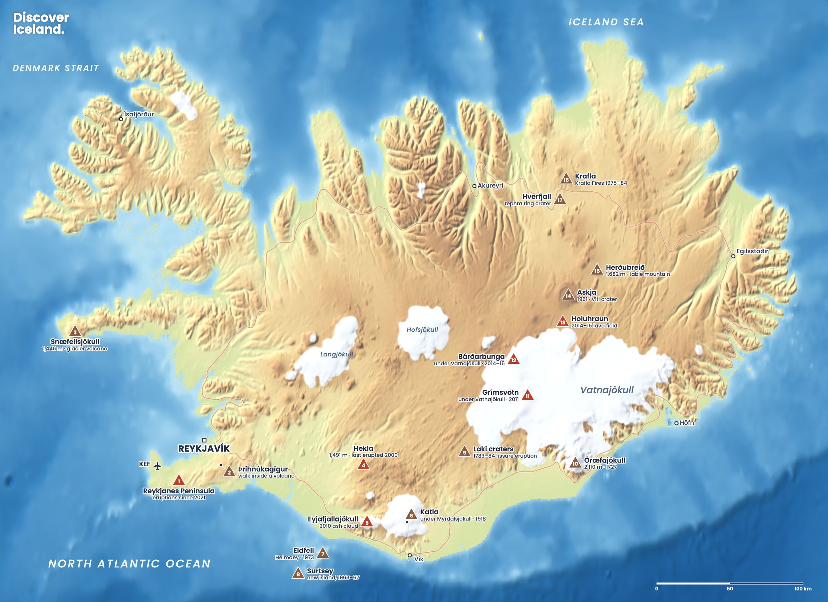
Yes, to the older Fagradalsfjall lava fields and to viewpoints over the Sundhnúkur lava. Visit Reykjanes, the regional tourist board, lists five marked trails from two official car parks: P1 at Geldingadalir and P2 at Stóri-Leirdalur.
| Trail | Goes to | Distance | Difficulty |
|---|---|---|---|
| Path A | 2021 and 2022 eruption sites, Fagradalsfjall | About 6–8 km one way, 2–2.5 h | Moderate to hard |
| Path B | Edge of the Sundhnúkur lava, with views of the craters | 4.7 km (B1) or 6.1 km (B2) one way from P1 | Moderate |
| Path C | Langihryggur viewpoint over the 2021–23 lava | About 4 km one way | Moderate |
| Path E | July 2023 site near Litli-Hrútur | About 18–20 km return, 5–6 h | Hard; last 2 km on rough lava |
| Nátthagi | Edge of the 2021 lava field | About 2 km one way | Easy |
Parking costs ISK 1,000 per car for 24 hours, paid through Parka.is (checked October 2026). Each car park has its own payment link, and unpaid cars get an extra fee. The paths are rough and exposed, so wear hiking boots and windproof, waterproof layers, and take water and food.
What are the rules at the eruption sites?
The main rule is simple: never walk on the new lava. Lava that looks solid can still be dangerously hot under a thin crust, and walking on it is not allowed on Paths C and E. The other rules come from the police and SafeTravel:
- Stay on marked paths and keep well back from lava edges, which can collapse or start moving again.
- Check the gas forecast before you set off. Volcanic gas can be invisible and odourless, and it collects in valleys and hollows. Keep to ridges, and leave at once if you feel unwell.
- Children under 12 are not advised to visit when gas pollution is present. Leave dogs at home: gas and fluorine pollution are unsafe for them.
- Respect closures. Police can close the area without notice, and the Sundhnúkur craters themselves are in the restricted zone.
- Do not go in bad weather or the dark. In winter the trails are icy, daylight is short and there are no lights.
Can you visit Grindavík?
Yes, at the time of writing, but with restrictions that can change at short notice. Grindavík, a fishing town, was evacuated on 10 November 2023 when magma was found running beneath it. Lava destroyed three houses in January 2024, and large earth barriers now protect the town and the Svartsengi power station.
The town reopened to the public on 18 July 2025. The Met Office's hazard assessment of 30 September 2026 kept Grindavík in the "considerable" (orange) hazard category, slightly lowered after cracks in the ground were repaired. A new risk assessment for people inside the barriers was published on 1 October 2026. Fissures and damaged ground remain, so keep to open streets and obey every sign and closure.
Is the Blue Lagoon open?
Usually, but it closes during eruptions and when the risk rises. The Blue Lagoon sits at Svartsengi, right beside the eruption zone. It was evacuated during several eruptions in 2024, and lava covered its car park in November 2024. Check the lagoon's own website on the day of your visit, and have a back-up. Our comparison of the Blue Lagoon and Sky Lagoon covers the closest alternative, in Reykjavík.
What happens if it erupts while you are in Iceland?
For most visitors, very little changes. Keflavík Airport, about 20 km from the eruption zone, has kept a normal schedule through every Reykjanes eruption, because these fissure eruptions release lava and gas but little ash.
Close to the eruption, expect road closures around Grindavík and Svartsengi, a closed Blue Lagoon and changing access to the trails. Authorities decide when and where people may watch. If you want to see an active eruption, the safest way is with a licensed tour operator that runs trips only when the area has been cleared. Sign up for SafeTravel's SMS alerts, and follow our Iceland volcano safety guide for gas, closures and flights.
How do you plan a visit to the Reykjanes lava fields?
- Check the status on vedur.is and closures on safetravel.is the evening before and the morning of your visit.
- Check the weather and gas forecast. Wind and rain make the trails hard going; wind direction decides where gas drifts.
- Pick a trail that fits your time. Nátthagi or Path C for a short visit, Path A for the classic 2021 craters, Path E for a full day.
- Pay for parking at P1 or P2 through Parka.is.
- Combine it with the rest of the peninsula. Þríhnúkagígur and the Raufarhólshellir lava tunnel are close by; see our lava tunnel guide.
The Reykjanes eruptions are part of the same plate boundary you can see at Þingvellir on the Golden Circle. For the rest of Iceland's volcanoes, from Hekla to Krafla, see our guide to volcanoes in Iceland.
Facts checked October 2026, using the Icelandic Met Office update of 30 September 2026 and travel updates to 12 October 2026. Activity on the Reykjanes Peninsula can change within minutes: always check vedur.is and safetravel.is before you go.
Sources
- Situation on the Reykjanes Peninsula, 30 September 2026 (Icelandic Met Office)
- News (Icelandic Met Office)
- Iceland volcano 2026 updates (Icelandic Mountain Guides)
- Reykjanes eruption timeline 2021–2026 (Volcano Express)
- Hiking trails to the eruption sites (Visit Reykjanes)
- Safety information (Visit Reykjanes)
- Grindavík reopens to public following eruption risk review (Iceland Review)
- 2023–2025 Sundhnúkur eruptions (Wikipedia)